
A few months ago, Kespry opened up its doors to supporting third-party drones such as the DJI Mavic 2 Pro and Phantom 4 series. The new platform-based model was set in motion to allow more flexibility and options to collect drone-based site survey data across multiple sites. Kespry added even more flexibility by creating a partnership with DroneBase. With this partnership, customers who don’t have access to their own drone, want to fly sites on an as-needed basis, or need additional resources for surveying, can simply hire a DroneBase pilot to fly the site(s).
The key advantage of gaining actionable insights from drone-based surveys comes from the capabilities of the data analytics platform. DroneBase pilots fly their drones or specified drones and capture data completely within the Kespry ecosystem in order to retain the highest level of accuracy and reliability customers are used to. Data collected from DroneBase is automatically processed and handled by Kespry and placed into the customer account shortly after the flight.
Below are a couple of use case scenarios that illustrate how using DroneBase can help support business initiatives within an existing or future drone-based survey program.
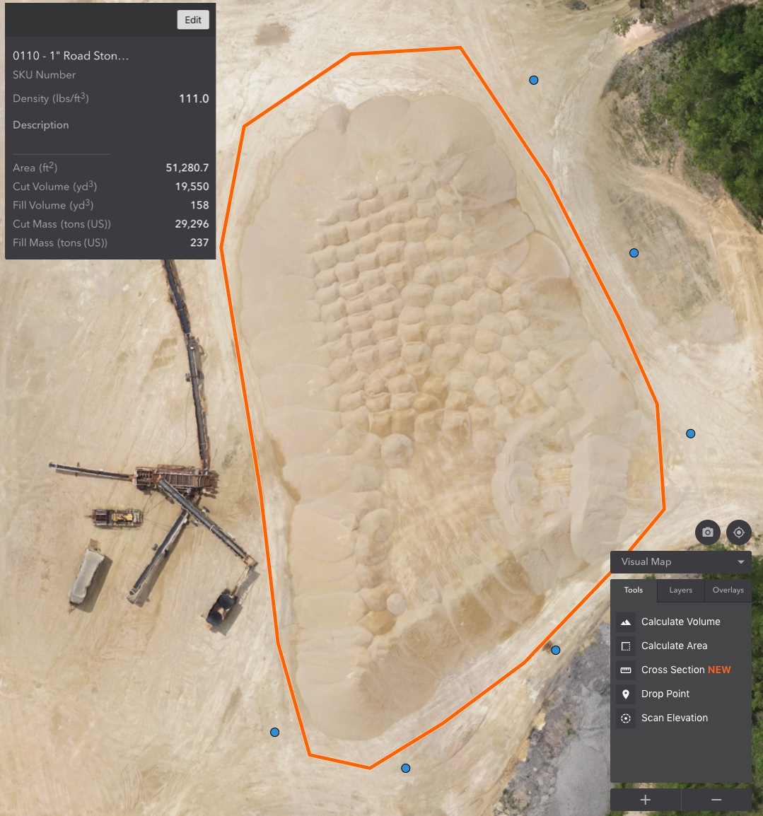
Aggregates and Mining Scenario:
Current Status: Company has a total of 10 inventory management sites, 8 sites have the resources to survey with their own drones on a regular basis and 2 sites have none or limited resources.
Situation: Company is looking to improve audit results across all sites and reduce inventory write-downs by surveying more frequently with drone-based surveys.
Recommendation: Purchase a “mapping” DroneBase Flight Pack to cover full-time surveys on the 2 sites with limited resources and on an as-needed basis for the other 8 sites.
Inspection Scenario:
Current Status: Company has 5 risk managers who handle most of their residential property risk management inspections. Overflow inspections are outsourced to a third party to reduce expenses.
Situation: Company wants to ramp up its drone inspection initiative. Each risk manager inspects 50 properties per year. Company has identified 30 properties deemed too costly to inspect using an internal risk manager based on the regional spread.
Recommendation: Purchase a “residential” DroneBase Flight Pack to cover the additional 30 properties while each risk manager flies their own assigned drone for the 50 properties in the annual inspection.
The DroneBase pilot network benefits when using with Kespry:
- 72 hour data turnaround time – based on the type and location of the flight
- All data output on the Kespry Cloud
- Same white-glove Kespry support
- Availability in all 50 states
- Seamless scheduling through Kespry
- Pilots use automated flight plans designed to mimic your normal Kespry flights
- All pilots are part 107 certified and held to certain professionalism standards
- All pilots are trained and certified according to Kespry flight procedures
- Most experienced and largest pilot network in the country
- The only pilot network that can scale to enterprise organizations
The Kespry and DroneBase program serves all the industries and applications purpose-built for the Kespry Platform – accurate inspection, inventory management and earthwork operations and mine planning. Companies that are looking to supplement their existing drone program with help from DroneBase pilots experience seamless data integration into their ongoing site survey work.