Drone-Based
Aerial Intelligence
The complete drone analytics solution to inspect, measure, analyze and report visual data needed to make better decisions
The complete drone analytics solution to inspect, measure, analyze and report visual data needed to make better decisions
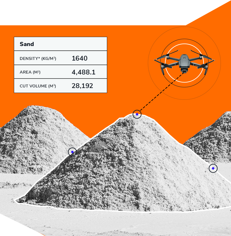


Kespry's drone-based aerial intelligence platform enables enterprises to transform how they capture, analyze and share insights about their business, providing the information needed to accelerate their operations. Purpose-built for industrial use, Kespry's platform delivers the data needed to close claims faster, measure stockpiles, survey mines more accurately, and operate earthworks projects more efficiently, all while being simple enough for any user.
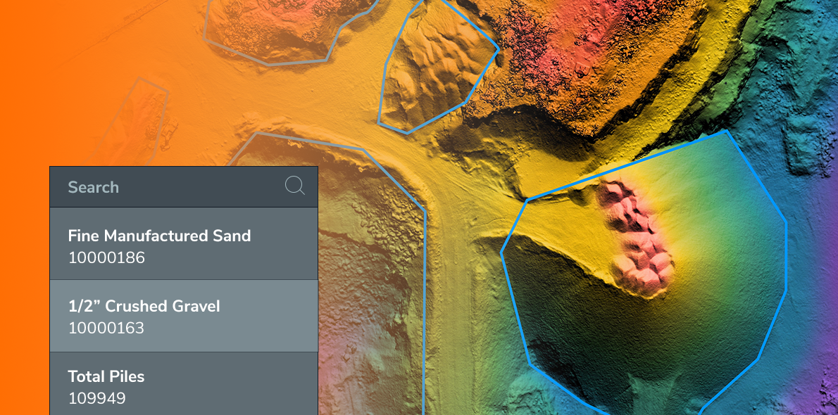
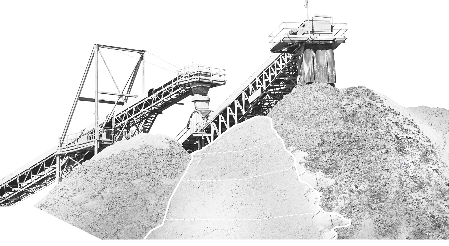
Aggregates and mining industries have transitioned from using drones for single-use cases to standardizing on them company-wide to drive their entire businesses. Unlocking the full potential of drone-based data with Kespry enables teams to frequently capture data across multiple departments and sites for mine planning, inventory management and on-site operations, creating a single source of truth any team member can tap into, anytime.
Learn More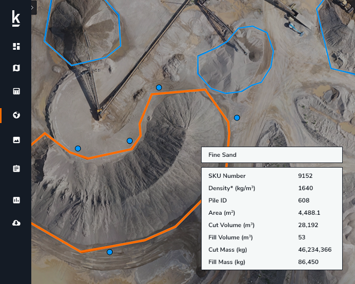
Drone-based aerial intelligence enables production plant and production managers to accurately analyze stockpile inventories, better manage supply chain activity and improve site operations - maximizing profitability across production and supply chain operations. Kespry's easy-to-use automated solution, backed by comprehensive support and training, enables Pulp & Paper organizations to boost productivity at every site.
Learn More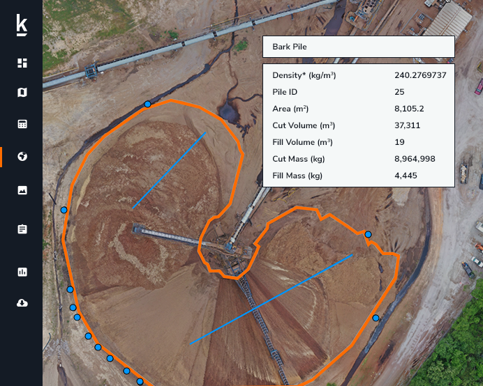
Processing industries such as Oil & Gas, Chemicals and Energy require daily and regularly scheduled site inspections, and Kespry's drone-based aerial intelligence platform offers an accurate and easy-to-use solution. A single 30-minute or less drone flight across the entire site is used to monitor the condition and quantities of storage tanks, buildings, pipelines, access roads and stockpiled materials with centimeter-level accuracy.
Learn More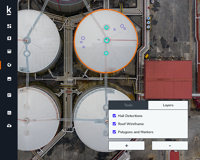
Kespry provides a complete solution for construction and engineering companies to better manage proposed and active earthwork operations. Without using multiple, cumbersome ground control points, survey-grade field data can be collected for an entire site in as little as 30 minutes.
Learn More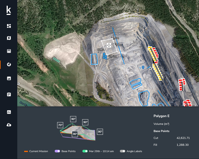
We’re trusted by our customers because we provide a drone data and analytics solution for market leaders in mining and aggregates, insurance and roofing businesses. The Kespry platform is easy to deploy in the field, and delivers the accurate data needed to close claims faster, measure stockpiles more accurately, survey mines more efficiently and optimize roof inspections, giving our customers the insights needed to make better business decisions.
You can find more details on how the Kespry platform works below –
How it WorksWe run a Kespry report every month and give it to plant managers and executives within our company to be able to track exactly how much material they have at any point in time. It helps our sales team to know exactly how much material we have to sell or if they need to get more of a certain type of material to fulfill an order.
Kris Lawson
Survey Manager, RK HALL
We’re able to sit in front of our key stakeholders, run through the data, show them how the calculations were done and identify any possible issues. Kespry has helped us a lot with people’s comfort level and trust in the data.
Chris Pike
Mining Engineer, Shelly Company
The Kespry Cloud is awesome. I can look at all of our locations in one place and get fast access to all the data. It’s a really great communication tool as well. We use it in meetings with upstream management, contractors and our hourly employees to show them mine plans and real-time photos.
Jerry Adkins
Senior Production Manager, Midsouth Paving
We do like the drone technology. Not only is it safer, but it's quicker and more accurate.
Don Rosenbarger
Business Development Manager, Delta Companies Inc.

I love the fact that I can go to one of our sites, fly the drone and then look at the data the same day and use it to work on mine and rehabilitation planning.
Jen Bernard
Land and Resource Coordinator, St. Marys CBM
What’s nice about the Kespry system is we can knock out an average inspection within about 15 minutes. Without a drone, a roof inspection can take up to two hours. With the drone, I have the data right there. I can look at it on-site and actually make some decisions on the spot, which is nice. Our policyholders and contractors have trusted the data and found that it is accurate. It makes us feel like we’re doing our job and getting policy holders taken care of. We’re making good on the promise we make to our policy holders.
Chuck Tremain
Property Large Loss Specialist
Kespry picks up everything, with detailed photos down to the granule. You clearly can see hail and we can zoom in and see the damaged areas. The data is good. It's great for presentations.
Phil Pratt
Partner, XAP 360
Kespry technology allows me on a weekly or even daily basis to get very accurate stockpile measurements of all the different sized aggregate products I have available.
James Veakins
Quarry Manager, Hanson UK
Kespry allowed us to bring inventory all in-house. We can fly sites whenever we want to, get photos any time we need them, and measure our stockpiles whenever we want to.
Ken Kampman
Survey and Operations Manager, Fred Weber
Ready to see how Kespry’s drone-based Aerial Intelligence platform enables you to rapidly and accurately survey and analyze stockpile inventories, comprehensively track large-scale worksites across industries, and inspect residential and commercial rooftops? Request a demo now and we’ll show you how our platform can work for you.
Request Demo