An Interview with Dan Liechty, Project Engineer, D&T Excavation
D&T Excavation is an earthwork contractor based in Sherwood, Oregon. D&T’s clients include commercial, residential, and government agencies. The company has experience in site preparation, site utilities, and stream enhancement. Dan Liechty is a Project Engineer at D&T Excavation. Dan has a background in GIS (Geographic Information Systems) and recently took ownership of D&T’s new Kespry Drone System.
We met with Dan to talk about D&T’s new Kespry system:
Kespry: I understand that the Kespry solution was recommended by Papé Machinery. Can you tell us about your relationship with Papé?
Dan: We have a really good relationship with Papé. They’re our John Deere dealer and we have a longstanding relationship with them for equipment. I think one of the deciding factors and going with Kespry was the John Deere and Papé partnership.
Kespry: What other companies did you look at for drone solutions? And what was the deciding factor for you to choose Kespry, besides the Papé recommendation?
Dan: We looked at another drone company that is a piecemeal solution. You get a drone that’s manufactured by somebody else. They help you put the camera on it and hook it up to an iPad, then you get some software to do analysis, and you have to go out and put ground control points down. It seems like from our research that you guys were the most complete, end-to-end solution.
Kespry: How are you going to apply Kespry to your work?
Dan: We will use Kespry to check existing conditions before we start a job, or even when we are bidding a job to be able to go out and verify existing elevations on a job site. A lot of times, the existing contours or elevations we’re getting from an engineer could be old or outdated or based on some inaccurate survey techniques.
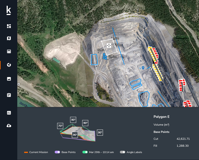
We plan to use it to topo a job site whenever we want to determine where we are on a job or how far we have to go. Once a week, or even daily, we can do a progress topo and be able to quickly determine where work still needs to be done.
We also saw the benefit of being able to invite customers to look at specific jobs or specific parts of the cloud information, and show them the progress and orthomosaic photographs.
Kespry: You mentioned using Kespry in bidding a job. Can you explain that use?
Dan: Just being able verify the accuracy of what you’re getting into. I think that’s everyone’s biggest nightmare: to bid a job and then find out that it’s different than what you were expecting. There’s supposed to be all this dirt; then it ends up not being there…you know, things like that. We can verify that ahead of time. We can go out there and verify it without spending two or three days doing a topo with a base and rover.
Kespry: Can you tell us about your prior process? How would you have done this work before you had Kespry?
Dan: Before Kespry, we would take our GPS rover out and spend the time walking or attaching it to us side-by-side, or a four-wheeler or pickup. Then we would go out and hit as many points as possible. The problem is it’s a big investment, time-wise. It’s fairly expensive to send a couple guys out there for multiple days. You’re not getting the information for several days after you start, and you’re still not left with a whole lot of data points in those places where people can’t go.
Kespry: That’s another really good point. You mentioned ‘places where people can’t go’. Another benefit with Kespry is that people talk about it being a much safer alternative, right?
Dan: Yeah, safety and time. I mean, with topo and measuring stockpiles, its a huge pain to send somebody to the top of a rock stockpile (or any stockpile) and to come down two or three hours later with only 15 topo points, compared to hundreds or thousands with the drone.
Kespry: Why is it important to be able to measure inventory stockpiles in your work?
Dan: For us, it would mostly be verifying what’s on the site to begin with or verifying a stockpile that’s on the site during the job. If we ordered X tons of rock, and we have truck tickets that say that 5,000 tons was delivered; we could use the topo to verify that. We’re not relying on our subcontractor information or our truck tickets, which don’t tend to be accurate.
Kespry: Verifying delivery of materials is a great use case for Kespry. Do you also manage inventory stockpiles in your recycled concrete business?
Dan: Yeah, I think that’s going to be big. Right before we got the drone, we had a guy go out there with the base and rover and topo some of those piles after they were crushed. I think the drone will definitely be really useful for that. You crush up however many tons of recycled concrete and then you’re going to sell it or use it on a job. It’d be handy to have accurate measurements on exactly what you have there. So I think that’s one of the areas where we see Kespry being really useful.
Kespry: Are you integrating Kespry with your existing software and processes?
Dan: During the initial process, we worked with AGTEK and Kespry, which was really cool for us because we use AGTEK a lot. It seems like Kespry definitely understands that to succeed in construction you have to integrate with the products that people are using, like AGTEK and the different GPS systems. So, I think that’s a huge benefit.
Kespry: Have you discovered any new applications that you weren’t planning on when you first decided to use Kespry?
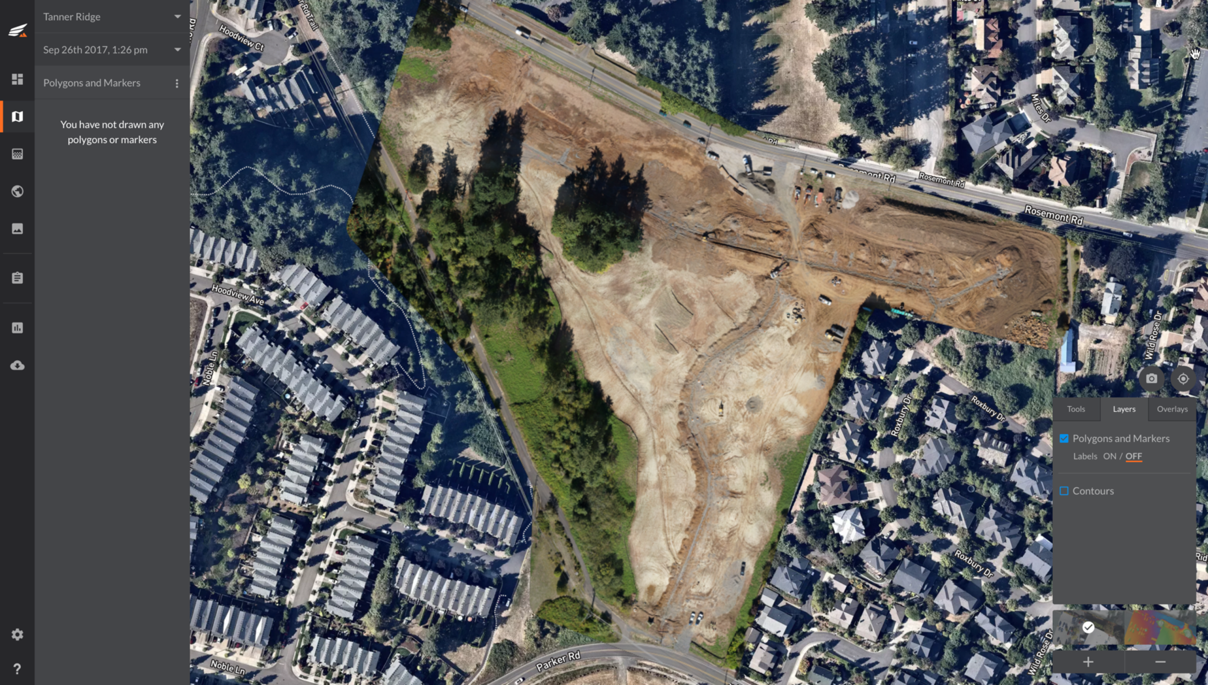
Dan: Yes, verification of quantities is one area that we didn’t really think about so much at the beginning, but it becomes pretty obvious pretty fast. We were trying to verify asphalt and curb quantities for our Tanner Ridge job. It’s a subdivision down the road, and we get a bill from our subcontractor for however many tons of asphalt and quantity of curb and gutter. We know that estimates are generally not super accurate. When you measure the pavement area, you have to break it up into squares and triangles, which doesn’t accurately reflect a cul-de-sac. So, we could use the drone data to quickly verify quantity – it’s super easy. I just snapped a line down all the curbs and just made a polygon around the gutter lines to verify the area of asphalt and the curbs.
Kespry: It’s great when customers discover the versatility of the Kespry solution. Once you start flying more, you’ll find even more applications for it.
Dan: I think that’s definitely true, and we realized that a little bit at the beginning. We think this is the future and that everyone’s going to be using something like this. We know once we start using it and Kespry keeps developing new tools, there’s going to be many more uses that we’re going to discover down the road.