While technology for mapping large greenfield sites has advanced from planes to global positioning to drones, depending upon the system used, a firm’s methods could be stuck 15, 30, or 50 years in the past.
Manned aerial systems and GPS techniques requiring numerous workers are quickly becoming a thing of the past. In a world where quicker access to info saves money, traditional methods require substantial time to capture, process and share data that has been collected. But the latest in technology—Kespry Drone 2s—provides an intuitive, enterprise drone mapping system that produces topographic data faster and more accurate than ever, complete with an enterprise cloud platform.
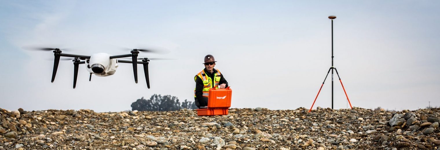
Kespry offers an accurate PPK (Post Processed Kinematic), fully integrated (hardware and software) and completely automated solution. Controlled with a few taps on an iPad, the Kespry Drone’s flight plan is quickly configured, and all data is automatically uploaded and processed within the online Kespry Cloud after a flight.
Getting Actionable Insights from Big Data
Companies undertaking mapping but not using current drone technology are risking productivity loss and increasing potential mistakes. By dispatching teams to map sites with labor-intensive GPS systems or legwork-inducing multiple scanner placement arrangements, some firms are inducing complacency and potential errors over greater accuracy and efficiency.
Progress Tracking in the Kespry Cloud
With the Kespry Drone 2s, companies achieve big savings through their mapping. By conserving employee time and company resources through benefits like fast training in use and setup of the system, less time spent in site surveying and less manpower used, greater accuracy of results and speedier delivery of analysis, companies adopting Kespry immediately see quicker workflows and healthier profits.
Adopting current drone technology is a matter of embracing the Big Data Era. The opportunity to analyze project sites and get accurate info, with quick setup, a dedicated success manager for every customer, faster data results and improved accuracy is a matter of saving money through innovation.
Firms using a Base and Rover system, or a consumer drone with third-party software, are spending much more time than if they were using Kespry’s fully integrated and automated aerial intelligence platform, which includes the Kespry Drone 2s and online Kespry Cloud.
Save time, manpower and operating expenses with the Kespry Drone 2s:
– While setup of a typical Base and Rover system and setup of Kespry’s system both can take as little as five minutes, there’s a big difference in time needed to go from data capture to actionable info.
– Surveying a 30-acre site with a Base and Rover system can take three to five days; Kespry Drone 2s can handle it in 20 minutes, automatically uploading the captured data into the online Kespry Cloud for users to access just a couple hours after the survey. Kespry Cloud data can be downloaded in more than 30 formats used for civil designs, geospatial analysis and other workflows requiring AutoCAD, SHP files, OBJ files and GeoTIFFs, among others. Users can calculate the volume and slope of any chosen surface, including cut and fill areas and more. Users can quickly verify elevation of a surface, starting with a simple check box. High-resolution images are automatically collected by the Kespry Drone 2s and post-processed into sub-centimeter resolution geotagged 3D models.
– Kespry’s data processing is automatic and faster—taking hours instead of days. With a base and rover system, data processing is manual and can take several days to generate a comprehensive topographic map, and companies using a third-party drone and their own software must assign a dedicated computer to process data for over a day. In construction, where margins are small, wrongly estimated or performed work means re-work that whittles away profits.
– Kespry’s accuracy is provided in an easy to use system. With a Base and Rover system, accuracy is 1-3 cm but is limited on number of points and requires substantial time to collect data; with other third-party drone systems, multiple control points/aerial targets must be incorporated to achieve 2 cm to 10 cm accuracies causing additional on-site and data processing with potential data warping. Kespry’s system only needs a single control point, has controlled data processing and is accurate within 2 cm to 10 cm. No visual recognition of targets (lowers accuracy) is necessary.
The Kespry advantages are streamlining how civil engineering projects are planned and how they progress.
“The Kespry Cloud, fueled by daily Kespry UAV flights, allows us to measure and communicate daily progress across our construction sites.” – Peter Sosnowski, Preconstruction Director, Webcor Builders
To learn how leading companies are seeing a clear ROI from the Kespry Aerial Intelligence Platform, contact us.